Nuang, the "Half-Trans"
As part of the training for the coming TMBT100, my running buddy UuBan has suggested to do a "trans" Nuang originally scheduled to be on 25/8/2013. However, thank to the block of long Hari Raya holiday, many trekkers/runners from other running groups planned to trek on the second day of Hari Raya (9/8/2013) at Gunung Nuang, UuBan suggested to follow the pack for our "trans Nuang" on the same day.
This post is more about my "Half Trans-Nuang" preparation rather than an accord of the whole journey.
To do a "trans Nuang", we start from Ulu Langat --> acsend to Gunung Nuang submit --> descend to Janda Baik --> ascend to Gunung Nuang submit (again) --> descent to Ulu Langat.
The GPS profile for the trek can be found here http://connect.garmin.com/course/3573453.
According to a source (http://vesparunner.blogspot.com/2013/05/trail-route-pangsoon-nuang-janda-baik.html#!/2013/05/trail-route-pangsoon-nuang-janda-baik.html), the profile of the trek is:


This post is more about my "Half Trans-Nuang" preparation rather than an accord of the whole journey.
What is "Trans Nuang"
Gunung Nuang is the highest peak in Selangor, situated at the intersection of Selangor, Pahang and Negeri Sembilan. There are 3 trails to the submit of Gunung Nuang. We can trek to the peak of Gunung Nuang either via Ulu Langat (most popular and difficult) in Selangor, or Janda Baik in Pahang, or Gombak (least popular).To do a "trans Nuang", we start from Ulu Langat --> acsend to Gunung Nuang submit --> descend to Janda Baik --> ascend to Gunung Nuang submit (again) --> descent to Ulu Langat.
The GPS profile for the trek can be found here http://connect.garmin.com/course/3573453.
According to a source (http://vesparunner.blogspot.com/2013/05/trail-route-pangsoon-nuang-janda-baik.html#!/2013/05/trail-route-pangsoon-nuang-janda-baik.html), the profile of the trek is:
DISTANCE : 38.65km
ELEVATION GAIN : 2,907m
MAX ELEVATION : 1,419m
MIN ELEVATION : 177m
I physically and mentally unprepared for the "full" "trans Nuang" yet when the plan was drawn. For the training, I was aiming for the "half" version of "Trans Nuang" which U-turn at Chemeroh Waterfall instead of the trail end of Janda Baik route.
The outing turned out to be tougher and longer (in terms of time, not distance) than TMBT50 last year, and the second longest "time-on-feet" of my life. What a "training"!
New weapons
After the surprise and lesson learnt from my first visit to Nuang almost 2 weeks ago, I was humbled and tamed by the many slopes and gradients at some parts of Nuang. A few weapons have been added to the arsenal for the upcoming battle:
1. A better pair of trekking shoes with spiky profile. During my first visit to Nuang, I slipped many times and finally sprained my left ankle left me with zero running mileage for 10 days.
2. Waterbag with tube. During my first visit to Nuang, the water bottles fell out from the side pockets of the backpack each time I did a pulling-up or jumping-down, until I have to put them back into the backpack. I have to stopped very frequently each time when I drank.
3. Brighter (80 lumens) and waterproof headlamp. This would be the first time I trek in the complete darkness.
4. Knee protectors. I didn't use them as they are intended for. I wrapped them around my calves as a "poor man" substitute for compression sock and for protection against cut.
5. Ankle protector, for my sprained elephant left ankle.
6. Walking stick. I knew it is useful but eventually, I didn't use it. I just didn't know why I intentionally left it in the car? Pure arrogance?
7. Handphone pocket. I was expecting calls during the long-hour trek with minimum signal coverage, hence quick access to handphone is important.
The packing list
This is also a close simulation of what I will bring during TMBT100...

For the "fuel", I was experimenting new food like raisin and fruit cake. Raisin turned out to be nicer than chocolate bar.
For pure "entertainment" purpose, I tried various varieties of chocolate bars as I have been eating Picnic for too long.
In addition to the tubed-waterbag, I also brought another 2-liter waterbag for refill on the way.
And my trusted camera (not in the photo, of course)!
The attire
The following is what I planned to wear/change during the coming TMBT100...

The socks were not in the photo.
For the training, I wore doubled layers of sock. A pair of shorter sport socks inside and another pair of thinner (but longer) socks outside. So, my left ankle was wrapped like a chinese rice-dumpling (粽子) with 3 layers of fabric.
Left and right calves was protected against fatigue and cut by "poor man" compression wear, which surprisingly worked very well.
Just in case I got lost and was forced to stay overnight in the forest, I also brought a pair of sweater, raincoat and reflective jacket (to help rescue operation, just in case).
I didn't expect to use the cap for this trip. However, it is a mandatory item for TMBT100. For simulation purpose, I give the cap a free riding trip.
Things I should have brought
1. Handphone portable battery charger. I found out that there is only phone reception (Maxis) at the peak and certain trail on the Janda Baik side. For most of the time, the phone was still actively transmitting in search of radio signal. As such, the battery depleted faster than before even though I made only 3 calls, all on the Janda Baik side.
2. Muscle pain relief (Deepheat, Counterpain),
3. ORS, plain forgetful!
4. Honey, how could I forget this?
5. More dried fruit. Swee Kiah shared his dried fruit (dates and fig, 无花果) with me. I shall tried these food next time.
6. Dried meat.
7. Contact lens.
7. Contact lens.
The Journey
We need to be at Nuang park by 4:30am, I planned to have my very early breakfast at McD before heading to Nuang.
I woke up at 2:30am and left the house at 3:15am. No, I didn't see the "good brothers" despite the 7th-month of Lunar calendar.

Reached McD by 3:30am. Order the McDeluxe set for consumption in the car, and take away an extra McDeluxe to be brought to the Nuang peak as lunch, I started my 45 minutes drive to Nuang Park.
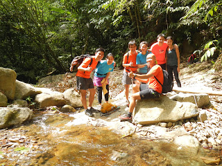
Everyone was there before 5:00am. After quick preparation and group photo, we hit the trail at 5:15am.

Another group photo at the start... (photo courtesy of Swee Kiah)

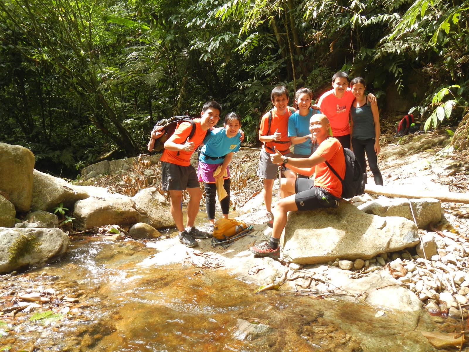
From the photos, 5 of us were aiming for "trans". The rest were aiming for the peak with some of them were attempting the peak or being at Nuang for the first time. I found out later that there were 3 more persons from other group attempting to "trans" too.

From the photos, 5 of us were aiming for "trans". The rest were aiming for the peak with some of them were attempting the peak or being at Nuang for the first time. I found out later that there were 3 more persons from other group attempting to "trans" too.
Unlike my previous trekking, due to fear of unknown and time-wasting, not many photos were taken except at Chemeroh Waterfall (where I had my lunch and longer rest) and Camp Pacat (on my way back).
1st Quarter, UluLangat to Nuang Submit
Journey to Camp Lolo was done in complete darkness. I took the opportunity to try out the long v.s. wide setting of the headlamp in the wild. UuBan, Swee Kiah, Ms. Leong and myself were in a group, with Foo and Dr. Wong about 10 to 20 meters behind us. UuBan and Foo were also busy laying paper trail for the remaining tailing trekkers.
We reached Camp Lolo at about 6:30am. Campers at the camping ground were still in their dreamland. We continued our journey without stopping.
The route become narrower and we could no longer walk side-by-side as before, but in a queue with Swee Kiah being the first and I was the last.
Suddenly, the black dog that had been following us from the base started to bark and scuffling was heard. Front trekker, Swee Kiah, stopped and everyone at the back followed. Not knowing what was happening, I moved forward and found out that the dog was fighting with a snake right in front Swee Kiah. Swee Kiah was seen taking video of the "Discovery Channel" scene and others started to take out the camera for shooting too. Thank to the "man's best friend" that we are spared from the possible lethal "kiss".
The sun rise when we were on our way to Camp Pacat. As the sky brighten up, the group up their pace except me. I tried not to let my heart rate went too high as I still had a long long day ahead. Five of them ahead of me slowly disappear from my view before we reach Camp Pacat.
I reached Camp Pacat in complete daylight at where I met only Foo and Dr. Wong. I urged them to move on as I wanted to take a short break and to take the trail slowly.
Along the way to the peak, I met a trekker-in-red who was trekking up alone with friends camped at Camp Lolo, and a group of 4 young guys from Kajang who were suffering from cramp. They told me that they had started to attack the peak since 2am but lost their way somewhere.
I reached the False Peak (Puncak Pengasih) at about 8:30am. Exhausted, I had a short rest while filling my tubed-waterbag with more water, with quick swallowing of 2 mini egg-tarts and some raisins.
I reached the peak at about 9am. Miss Leong was the only one from the group still at the peak, with the rest had left for the descending journey to Janda Baik. I was told that they had left about 5 to 10 minutes ago.
The temperature at the peak was quite low with mild wind. I was not sure of the actual temperature but was shivering at times. In order not to catch a cold, I had another very quick bites on more egg-tarts and raisins while sharing some with the snake-killing black hero.
2nd Quarter, Nuang Submit to Chemeroh Waterfall
The journey to Chemeroh Waterfall was quite boring. The entering to the trail was quite dangerous. First, I had to try lowering myself down from a huge rock taller than a person using the rope that has been previously attached by someone. The landing area was just next to a cliff that I dare not to take a peek.
Then, there was a "horse back" passage with cliff on the left and right. I literally held my breathe while crossing the "horse back".


After the 2 initial obstacles, the rest of the descend was straight forward.
I reached Chemeroh Waterfall at 11:30am, 2 1/2 hours from the peak. There, I saw Dr. Wong tracing back from the Janda Baik side...

Dr. Wong told me that he did his "u-turn" from the "bamboo forest" (which I have no idea where is it) and was on his returning journey. UuBan, Swee Kiah and Foo were probably 15 minutes ahead, and most likely already at the trail-head of Janda Baik.
Met another group of trekkers (that I don't know)...
The tiny "waterfall", or should I say, "stream"...


Water was fast flowing and clear...
I was wondering the type of "life-form" in the water as I will be relying on the same water for the returning journey, so the following video...
Surprisingly, I don't see "life" in the water perhaps the flow was too fast.
My "lifeless" pair of "wheel" taking rest...

... and the "men's best friends" that have been following me from Ulu Langat since 5:15am...

I was busy feeding their "black buddy" who saved us from nasty snake-bite too.
Lunch time. McD's Chicken McDeluxe...


Shortly, I saw the familiar face of a Facebook friend appeared from the bush, the "fast and famous" Mr. Choo...

This is the first time that we met in person and formally introduced ourselves after knowing each other for a year in the Cyberworld.
Choo started his journey from Ulu Langat at 7:30am, 2.5 hour later than me. However, we reached Chemeroh Waterfall at almost the same time. (Later, Mr. Choo overtook me on the way back to the peak despite I left the waterfall 10 minutes earlier. He, eventually, finished at Ulu Langat trail-head almost 3 hours earlier than me! Salute to the 55-year-old senior trekker!).
As there is another out-and-back 1.5 hours journey to the trail-head of Janda Baik. A quick mental estimation told me that I could barely made it (if there is no "drama") before darkness if I proceed to Janda Baik carpark now. In order not to take unknown risk, I decided to "u-turn" instead of proceeding to Janda Baik trail-head.
After re-filling the waterbags and a total 50 minutes rest, it was the returning journey.
Before returning, I left a sign, made by tearing the "paper trail", to notify the front pack that I was safe and was on the way back...

At 2:40pm, after trekking for about 2 hours 15 minutes from the waterfall, I was back at the submit again.

There, I met Choo and UuBan again. They had their rest and prepared to descend back to Ulu Langat.
Shortly after Choo and UuBan had left, Swee Kiah appeared from the Janda Baik side of the trail. Swee Kiah shared with me his dried fruits (dates and fig) and suggested me to try during my next hike.
I also had some Kit-kat and final pack of raisins, and of course, my accompanies (Ah Whites and Ah Black) also had their shares from me. Besides, I top-up my tubed-waterbag with the final 2 liters of stream water from the spare waterbag.
At 2:55pm, both of us started our final stretch of journey, the descend from the peak back to Ulu Langat.
The stretch from the peak to Camp Pacat was more technically demanding which, at some places, I need to use all my four limbs to move forward. I tried resisting from jumping down nor to exert excessive impact on my ankles and knees, especially my left ankle.
For most part of the trail, I was walking downwards facing left bending my left leg while landing on my right foot at very slow pace. This was to minimize the impact on my left ankle.
After 1.5 hours trekking from the peak, I was at Camp Pacat. There, I finally saw the legendary signature tree of Gunung Nuang (that I missed during my first visit)...

I was very glad to see this tree in real. From most photos I saw in the Internet, I knew that the "signature" of Gunung Nuang will not survive for long as trekkers like to stand on the twisted branch posting for photos, which I think, is not advisable. If there is average of 500 trekkers visiting Gunung Nuang and stand on the branch every week, I don't think the tree can survive in it original form in the near future!
Shortly after Camp Pacat, I heard footsteps behind me some distance away. I stopped and looked back after hearing Foo called out to me. Foo was suffering from dehydration and bad body response to the gas-sy 100plus. Despite the dehydration, he managed to do the "full" version of "trans Nuang" and catch up with me. We decided to move on together in support of each other.
We took a short break at Camp Lolo and later at a shelter of the "never ending road". When moving at the "never ending road", I started to feel sore knee and slight discomfort on the left ankle which I tried to avoid for the training. Nevertheless, we moved slightly faster hoping to beat the sunset.
At 7:30pm and after trekking from the peak for more than 4 hours, and 14 hours 6 minutes in total, I finally got back to Ulu Langat park. UuBan (who did the "full trans Nuang" and has finished 1.5 hour ahead of me) and Lin Fong were waiting with their camera for our finishing shot...

Finally, I was fortunate to be back without much drama (touched wood!) despite the very slow pace. The crazy "training", without me realizing it earlier, turned out to be the second longest "time-on-feet" I ever done!
I am now looking forwards to the "full trans Nuang", which should be in the training agenda in 2 weeks time.
I reached Chemeroh Waterfall at 11:30am, 2 1/2 hours from the peak. There, I saw Dr. Wong tracing back from the Janda Baik side...

Dr. Wong told me that he did his "u-turn" from the "bamboo forest" (which I have no idea where is it) and was on his returning journey. UuBan, Swee Kiah and Foo were probably 15 minutes ahead, and most likely already at the trail-head of Janda Baik.
Met another group of trekkers (that I don't know)...
The tiny "waterfall", or should I say, "stream"...

The forest access towards the Peak...

Water was fast flowing and clear...
I was wondering the type of "life-form" in the water as I will be relying on the same water for the returning journey, so the following video...
Surprisingly, I don't see "life" in the water perhaps the flow was too fast.
My "lifeless" pair of "wheel" taking rest...

... and the "men's best friends" that have been following me from Ulu Langat since 5:15am...

I was busy feeding their "black buddy" who saved us from nasty snake-bite too.
Lunch time. McD's Chicken McDeluxe...


Shortly, I saw the familiar face of a Facebook friend appeared from the bush, the "fast and famous" Mr. Choo...

This is the first time that we met in person and formally introduced ourselves after knowing each other for a year in the Cyberworld.
Choo started his journey from Ulu Langat at 7:30am, 2.5 hour later than me. However, we reached Chemeroh Waterfall at almost the same time. (Later, Mr. Choo overtook me on the way back to the peak despite I left the waterfall 10 minutes earlier. He, eventually, finished at Ulu Langat trail-head almost 3 hours earlier than me! Salute to the 55-year-old senior trekker!).
As there is another out-and-back 1.5 hours journey to the trail-head of Janda Baik. A quick mental estimation told me that I could barely made it (if there is no "drama") before darkness if I proceed to Janda Baik carpark now. In order not to take unknown risk, I decided to "u-turn" instead of proceeding to Janda Baik trail-head.
After re-filling the waterbags and a total 50 minutes rest, it was the returning journey.
Before returning, I left a sign, made by tearing the "paper trail", to notify the front pack that I was safe and was on the way back...

3rd Quarter, Chemeroh Waterfall to Nuang Submit
The returning journey to the peak from Janda Baik side was somewhat easier than UluLangat-Peak trail. Best of all, there is handphone (Maxis) reception at some part of the trail. I received a few work-related missed-calls and smses 1 hour into the returning trail. I took the opportunity to rest and to reply the missed calls and smses. That was also the time when Choo (who was returning from the waterfall 10 minutes later than me) and UuBan (who was returning from Janda Baik trail-head) overtook me! Both of them were very fast.At 2:40pm, after trekking for about 2 hours 15 minutes from the waterfall, I was back at the submit again.

There, I met Choo and UuBan again. They had their rest and prepared to descend back to Ulu Langat.
Shortly after Choo and UuBan had left, Swee Kiah appeared from the Janda Baik side of the trail. Swee Kiah shared with me his dried fruits (dates and fig) and suggested me to try during my next hike.
I also had some Kit-kat and final pack of raisins, and of course, my accompanies (Ah Whites and Ah Black) also had their shares from me. Besides, I top-up my tubed-waterbag with the final 2 liters of stream water from the spare waterbag.
At 2:55pm, both of us started our final stretch of journey, the descend from the peak back to Ulu Langat.
4th Quarter, Nuang Submit to Ulu Langat
From previous experience, I knew that I need about 3.5 hours for the return journey. That means I could made it back to Ulu Langat park before the sunset.The stretch from the peak to Camp Pacat was more technically demanding which, at some places, I need to use all my four limbs to move forward. I tried resisting from jumping down nor to exert excessive impact on my ankles and knees, especially my left ankle.
For most part of the trail, I was walking downwards facing left bending my left leg while landing on my right foot at very slow pace. This was to minimize the impact on my left ankle.
After 1.5 hours trekking from the peak, I was at Camp Pacat. There, I finally saw the legendary signature tree of Gunung Nuang (that I missed during my first visit)...

I was very glad to see this tree in real. From most photos I saw in the Internet, I knew that the "signature" of Gunung Nuang will not survive for long as trekkers like to stand on the twisted branch posting for photos, which I think, is not advisable. If there is average of 500 trekkers visiting Gunung Nuang and stand on the branch every week, I don't think the tree can survive in it original form in the near future!
Shortly after Camp Pacat, I heard footsteps behind me some distance away. I stopped and looked back after hearing Foo called out to me. Foo was suffering from dehydration and bad body response to the gas-sy 100plus. Despite the dehydration, he managed to do the "full" version of "trans Nuang" and catch up with me. We decided to move on together in support of each other.
We took a short break at Camp Lolo and later at a shelter of the "never ending road". When moving at the "never ending road", I started to feel sore knee and slight discomfort on the left ankle which I tried to avoid for the training. Nevertheless, we moved slightly faster hoping to beat the sunset.
At 7:30pm and after trekking from the peak for more than 4 hours, and 14 hours 6 minutes in total, I finally got back to Ulu Langat park. UuBan (who did the "full trans Nuang" and has finished 1.5 hour ahead of me) and Lin Fong were waiting with their camera for our finishing shot...

Finally, I was fortunate to be back without much drama (touched wood!) despite the very slow pace. The crazy "training", without me realizing it earlier, turned out to be the second longest "time-on-feet" I ever done!
I am now looking forwards to the "full trans Nuang", which should be in the training agenda in 2 weeks time.
posted by YS at 5:49 PM
0 comments
![]()
![]()