Losing 'virginity' to Datuk, the Gunung
No, I have not changed the 'scope' of the blog. The space here is as healthy as before. This tiny (amid rusty) little corner is still like the title says: "Off Duty Electrician"... what I did when I was not holding a 'testpen' and 'multimeter'.
I had my first ever offroad hike at Gunung Datuk last Saturday (28,July,2012) thanks to Steve Yap's invitation.
The decision to join the hike came at the very last minute as I was not sure if I would be free on the hike morning. Was both mentally and physically un-prepared. I did not have any trail-hiking gear nor basic trail shoes. I was mentally treating the hike like a normal weekend long run training... except that, for this weekend, the running route is a little far from home.
However, the hike turned out to be an eye-opening experience and completedly change my perception of trail and mountain hiking, largely due to the fantastic climb group and the destination!
Gunung Datuk, the background
I did a little background search on the "Datuk" the night before the journey. From the map, it is located not too far from Rembau, which is a town halfway between Seremban and Tampin (my mum's hometown). However, I was not too worried about the exact where-about of the "Datuk" as we (Steve and the climb group) were supposed to gather at the Senawang toll before heading to the base.
From the internet, I found out the following facts about the "Datuk":
- Height at the peak: 884m;
- Height from the base: about 800m;
- Trail length (one way): 4.6km;
- Facility: basic toilet;
- Fees: RM5;
- Difficulty: (irrelevant to me, as I had no prior experience)
- Interesting facts: It is the highest peak of Negeri Sembilan (incorrect, check Steve's comments below). We will be able to see the Strait of Melaka at the peak if the sky is clear. We should be expecting to see wild mushroom, ants, insects, worm, centipede, millipede along the trail. There is a "footpring of Hang Tuah (some said Cheng Ho)" at the peak... I must check this out.
With these interesting facts in mind... was really anticipating the hike.
The Journey to the Base
Woke up at 4am, together with opening ceremony of Olympic 2012. Didn't bother to turn on the TV to had a peep at the Olympic 2012 opening because I know it would be another multimillion dollar fireworks, lights, torch... etc. Would leave that for the re-play. Had my usual routine before long run.
Left home at 5am. Planned to have breakfast at fast food restaurant at one of the R&R along Seremban highway. Was surprise that the McD near the Sungai Besi toll was so crowded with many Muslim friends queueing for their last meal before "Puasa of the day" started. So decided to move on instead of wasting time in the queue.
6am, was lucky that the KFC at the last R&R before Seremban was completedly empty. Had my quick and unhealthy breakfast before heading to the Senawang toll meeting point.
6:30am, reached Senawang toll. Saw a few cars parked at the side right after the toll. Not knowing anyone from the group except Steve, I parked my car next to an "uncle-in-sportwear"'s car, hoping that he is from Steve's group. Few minutes later, more and more cars with "driver-in-sportwear" came. I was quite sure that they must be from Steve's group. Broke the ice by approaching a lady seemed like a leader. Found out that she is Melissa mentioned in Steve's email. After a short chit-chating and wait... we started our remaining journey to the "Datuk's base".
From Senawang Toll, we took a right turn to the old Tampin road. This road brought back all my childhood memories. Back in the 70s and early 80s (before the begining of the Plus era), this was the only road (the windy and old) to go to my Grandmum's (mother side) house. This is the road that, as a small kid, I vomitted at the roadside a few times more than 30 years ago.
7am, after about half an hour drive along the wider and smoother Tampin road (compared to 30 years ago), we were at Rembau. A tall "gunung" appear before me. I guessed it must be the "Datuk" and managed to snap these...
...at Rembau with the 'flat-top' Datuk at the far background...

...and a clearer 'Datuk' with the beautiful glimpse of morning sun behind the 'Datuk'.

Five minutes after passing Rembau town, we made a left turn to road N111.
After about another 5km, we made another left turn into a palm/rubber trees plantation. The tarred road was narrow and windy but otherwise in good condition...
In 5 minutes, we were at the base.
By now, my car mileage meter showed 94km from my home. This is probably the furthest training run route from home.
The Base
The road leading to the carpark.
 The carpark is large enough for 20 to 30 cars, including 3 lots meant for buses.
Another view of the carpark. The registration counter (red roof) is on the left of the photo...

There is an eatery, but was closed...
 Was not sure if it is still in operation...most likely yes.
The climb group was having breakfast before the climb. The food was prepared by the group.
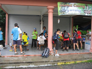
After the breakfast and a short briefing by the team leader, we headed into the wild.
The Trail
The trail started with a short descending to a small stream. After crossing a concrete bridge, it was all the way up with most of the trail having gradient more than 45 degrees. A large section was having gradient of more than 60 degrees.
The foliage was thick enough to block GPS reception. The sloppy path was mostly criss-crossed by tree roots forming the "natural steps" for climbers.
There were many spiders and insect along the trail. I managed to capture the photos/videos of some of these creatures in the wild...
...marching ants (many many of them)...
...Zhen will surely like this!
Overize ants, about the size of 2/3 of my thumb...

Oversize milipede...about the length of my GPS watch...
 The poor giant pede was earlier stepped by someone.
There are 2 damaged huts at about the halfway up the peak. Only the roofs survive. I think the roofs still can serve their purpose as rain-shelter... that might probably why they are still there.

Skinny little leech looking for prey...
There are many beautiful mushroom and fungus. As a typical Chinese that eats anything, I was tempted to have a taste of these interesting looking mushrooms especially some of them do look like the expensive Chinese herb called "lin zhi". However, I want, in the very near future, my children to be able to see these alive in the wild... the the conscious told me that we must protect these creature in the wild. Only idiot will eat them...especially if you are a climber.
"Lin Zhi" in the wild...

...more "lin zhi"...
 This one is having diameter of 1 foot!
Another beautiful "lin zhi"/fungus...

A Smurf house...

Smurf village...big cluster of mushroom...
 Wondered if we can find little blue creature under them.
Another Smurf village hides underneath a fallen tree...

After an hour exhausting hike up mostly slopes of more than 45 degree, we finally reached the camp site at the peak...

To reach the absolute pinnacle for breathtaking view, there were 2 more ladders to climb...
 The first ladder was easy...
...and the second ladder...
 Thanks to Mr. Yee (a 65-year-old uncle) for posing for the photo. The second ladder was long and shaky. The landing area at the top of the ladder was not flat. We have to hold on to a thick rope tied to the rocks to get ourselves up to the landing area...and it was scary initially. Not recommended for the weaker-heart.
This is what I meant...Steve (man in red) was trying to give himself a final pull up the pinnacle...

Finally, was at the pinnacle of Negeri Sembilan...
 ...with Kota town or probably Tampin at the background...not very sure. The far end should be the Strait of Melaka. Unfortunately, the cloudy weather block the seaview.
Managed to capture the 360-degree view at the pinnacle...
A breathtaking view...
 The houses on the left of the photo should be Rembau. Again, Strait of Melaka should be at the far end. The temperature was probably 25-28 degree while this photo was taken.
Dark cloud forming/dispersing on the top right cornet of the photo. The dark cloud was very near to us.

We (the first group that reached the peak) spent about 1 hour at the peak. Had hot coffee, cherry tomatoes, cucumber, capsicum (special thanks to Melissa and KG)... nicely prepared by the fantastic climb group!
Yes...I did see the footprint of "who-ever"...forgot to take the picture of the footprint. Was told that the mysterious footprint has been there when one of the group member reached the peak in the 60s.
Descending
We started to descend at about 11am.
The descending was very easy on the heart and lung, but taxing on the knee and thigh muscle, especially when I was wearing road-shoes.
The worse came when I had to land on slippery or smooth surface. I was forced to use extra strength to hold my two legs together... to avoid from making "acrobatic leg split", in Chinese, "one word horse". Most of the time, I had to be very cautious in choosing the landing spot to avoid twisting my ankle. It was no walking in the park.
I managed to capture the following when negotiating a section of rare flat surface on my way down...
By 12pm, we were back to the base again. The descending took about the same time as ascending...except Steve-the-ranger who spent only 1/2 hour (incorrect, check Steve's comments below) to complete the descend. Must learn the tactic from Steve.
 The photos was NOT taken at the base...but the peak! The incredible couple reached the peak with their 5-year-old son (Stewart) and 10-month-old baby girl (Alicia).
Alex and little Stewart were seen barefoot when I met them at the peak.
Little baby Alicia was probably the youngest human reaching the peak.
I fully respect the family.
The Incredibles posing next to giant boulder of the pinnacle...

Little Stewart and baby Alicia exploring the peak...
 Ants? What ants?!!
Mud? What mud?!!
Kid should not run barefoot in the wild??? You must be kidding.
Next climb, yes... with family along and binoculars.
I had my first ever offroad hike at Gunung Datuk last Saturday (28,July,2012) thanks to Steve Yap's invitation.
The decision to join the hike came at the very last minute as I was not sure if I would be free on the hike morning. Was both mentally and physically un-prepared. I did not have any trail-hiking gear nor basic trail shoes. I was mentally treating the hike like a normal weekend long run training... except that, for this weekend, the running route is a little far from home.
However, the hike turned out to be an eye-opening experience and completedly change my perception of trail and mountain hiking, largely due to the fantastic climb group and the destination!
Gunung Datuk, the background
I did a little background search on the "Datuk" the night before the journey. From the map, it is located not too far from Rembau, which is a town halfway between Seremban and Tampin (my mum's hometown). However, I was not too worried about the exact where-about of the "Datuk" as we (Steve and the climb group) were supposed to gather at the Senawang toll before heading to the base.
From the internet, I found out the following facts about the "Datuk":
- Height at the peak: 884m;
- Height from the base: about 800m;
- Trail length (one way): 4.6km;
- Facility: basic toilet;
- Fees: RM5;
- Difficulty: (irrelevant to me, as I had no prior experience)
- Interesting facts: It is the highest peak of Negeri Sembilan (incorrect, check Steve's comments below). We will be able to see the Strait of Melaka at the peak if the sky is clear. We should be expecting to see wild mushroom, ants, insects, worm, centipede, millipede along the trail. There is a "footpring of Hang Tuah (some said Cheng Ho)" at the peak... I must check this out.
With these interesting facts in mind... was really anticipating the hike.
The Journey to the Base
Woke up at 4am, together with opening ceremony of Olympic 2012. Didn't bother to turn on the TV to had a peep at the Olympic 2012 opening because I know it would be another multimillion dollar fireworks, lights, torch... etc. Would leave that for the re-play. Had my usual routine before long run.
Left home at 5am. Planned to have breakfast at fast food restaurant at one of the R&R along Seremban highway. Was surprise that the McD near the Sungai Besi toll was so crowded with many Muslim friends queueing for their last meal before "Puasa of the day" started. So decided to move on instead of wasting time in the queue.
6am, was lucky that the KFC at the last R&R before Seremban was completedly empty. Had my quick and unhealthy breakfast before heading to the Senawang toll meeting point.
6:30am, reached Senawang toll. Saw a few cars parked at the side right after the toll. Not knowing anyone from the group except Steve, I parked my car next to an "uncle-in-sportwear"'s car, hoping that he is from Steve's group. Few minutes later, more and more cars with "driver-in-sportwear" came. I was quite sure that they must be from Steve's group. Broke the ice by approaching a lady seemed like a leader. Found out that she is Melissa mentioned in Steve's email. After a short chit-chating and wait... we started our remaining journey to the "Datuk's base".
From Senawang Toll, we took a right turn to the old Tampin road. This road brought back all my childhood memories. Back in the 70s and early 80s (before the begining of the Plus era), this was the only road (the windy and old) to go to my Grandmum's (mother side) house. This is the road that, as a small kid, I vomitted at the roadside a few times more than 30 years ago.
7am, after about half an hour drive along the wider and smoother Tampin road (compared to 30 years ago), we were at Rembau. A tall "gunung" appear before me. I guessed it must be the "Datuk" and managed to snap these...
...at Rembau with the 'flat-top' Datuk at the far background...

...and a clearer 'Datuk' with the beautiful glimpse of morning sun behind the 'Datuk'.

Five minutes after passing Rembau town, we made a left turn to road N111.
After about another 5km, we made another left turn into a palm/rubber trees plantation. The tarred road was narrow and windy but otherwise in good condition...
In 5 minutes, we were at the base.
By now, my car mileage meter showed 94km from my home. This is probably the furthest training run route from home.
The Base
The road leading to the carpark.

Another view of the carpark. The registration counter (red roof) is on the left of the photo...

There is an eatery, but was closed...

The climb group was having breakfast before the climb. The food was prepared by the group.

After the breakfast and a short briefing by the team leader, we headed into the wild.
The Trail
The trail started with a short descending to a small stream. After crossing a concrete bridge, it was all the way up with most of the trail having gradient more than 45 degrees. A large section was having gradient of more than 60 degrees.
The foliage was thick enough to block GPS reception. The sloppy path was mostly criss-crossed by tree roots forming the "natural steps" for climbers.
There were many spiders and insect along the trail. I managed to capture the photos/videos of some of these creatures in the wild...
...marching ants (many many of them)...
Overize ants, about the size of 2/3 of my thumb...

Oversize milipede...about the length of my GPS watch...

There are 2 damaged huts at about the halfway up the peak. Only the roofs survive. I think the roofs still can serve their purpose as rain-shelter... that might probably why they are still there.

Skinny little leech looking for prey...
There are many beautiful mushroom and fungus. As a typical Chinese that eats anything, I was tempted to have a taste of these interesting looking mushrooms especially some of them do look like the expensive Chinese herb called "lin zhi". However, I want, in the very near future, my children to be able to see these alive in the wild... the the conscious told me that we must protect these creature in the wild. Only idiot will eat them...especially if you are a climber.
"Lin Zhi" in the wild...

...more "lin zhi"...

Another beautiful "lin zhi"/fungus...

A Smurf house...

Smurf village...big cluster of mushroom...

Another Smurf village hides underneath a fallen tree...

After an hour exhausting hike up mostly slopes of more than 45 degree, we finally reached the camp site at the peak...

To reach the absolute pinnacle for breathtaking view, there were 2 more ladders to climb...

...and the second ladder...

This is what I meant...Steve (man in red) was trying to give himself a final pull up the pinnacle...

Finally, was at the pinnacle of Negeri Sembilan...

Managed to capture the 360-degree view at the pinnacle...
A breathtaking view...

Dark cloud forming/dispersing on the top right cornet of the photo. The dark cloud was very near to us.

We (the first group that reached the peak) spent about 1 hour at the peak. Had hot coffee, cherry tomatoes, cucumber, capsicum (special thanks to Melissa and KG)... nicely prepared by the fantastic climb group!
Yes...I did see the footprint of "who-ever"...forgot to take the picture of the footprint. Was told that the mysterious footprint has been there when one of the group member reached the peak in the 60s.
Descending
We started to descend at about 11am.
The descending was very easy on the heart and lung, but taxing on the knee and thigh muscle, especially when I was wearing road-shoes.
The worse came when I had to land on slippery or smooth surface. I was forced to use extra strength to hold my two legs together... to avoid from making "acrobatic leg split", in Chinese, "one word horse". Most of the time, I had to be very cautious in choosing the landing spot to avoid twisting my ankle. It was no walking in the park.
I managed to capture the following when negotiating a section of rare flat surface on my way down...
By 12pm, we were back to the base again. The descending took about the same time as ascending...except Steve-the-ranger who spent only 1/2 hour (incorrect, check Steve's comments below) to complete the descend. Must learn the tactic from Steve.
The Incredibles
I met an incredible and inspiring couple, Alex and family (my codename: The Incredibles)...

Alex and little Stewart were seen barefoot when I met them at the peak.
Little baby Alicia was probably the youngest human reaching the peak.
I fully respect the family.
The Incredibles posing next to giant boulder of the pinnacle...

Little Stewart and baby Alicia exploring the peak...

Mud? What mud?!!
Kid should not run barefoot in the wild??? You must be kidding.
Next climb, yes... with family along and binoculars.
posted by YS at 8:19 AM
2 comments
![]()
![]()


